CartoGraphy
Deportation meant removal, distance, dispersal.
To represent the timing of these journeys, periods of exile and transport, the period spent waiting for the right to return, we have chosen a special way of mapping these journeys that combines time and territory, space and distance.
Two sorts of map are used:
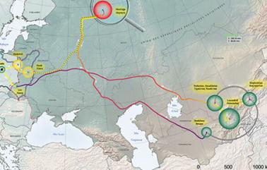
- Journeys into exile : Geographical maps over time of the journeys of those deportees whose testimonies we have. These include the period between arrest and arrival at the place of resettlement (with darker colours over time), the period in exile or imprisonment (shown as concentric circles with areas proportional to time), and the time until their return. Forced travel and journeys home, and types of transport are also indicated.
- Searchable datarich maps will provide a geographical entry into the data, along with the thematic and biographical entries. Search will be possible by the places visited by the people whose biographies we have, or by the themes they are classified under.
JOURNEYS INTO EXILE
DATArich MAPS